Here's something you might be interested in.
Ask a Hipster — Advice you didn't know you needed
Big Screen — Movie commentary
Blurt — Music's inside track
Booze News — San Diego spirits
Classical Music — Immortal beauty
Classifieds — Free and easy
Cover Stories — Front-page features
Drinks All Around — Bartenders' drink recipes
Excerpts — Literary and spiritual excerpts
Feast! — Food & drink reviews
Feature Stories — Local news & stories
Fishing Report — What’s getting hooked from ship and shore
From the Archives — Spotlight on the past
Golden Dreams — Talk of the town
The Gonzo Report — Making the musical scene, or at least reporting from it
Letters — Our inbox
Movies@Home — Local movie buffs share favorites
Movie Reviews — Our critics' picks and pans
Musician Interviews — Up close with local artists
Neighborhood News from Stringers — Hyperlocal news
News Ticker — News & politics
Obermeyer — San Diego politics illustrated
Outdoors — Weekly changes in flora and fauna
Overheard in San Diego — Eavesdropping illustrated
Poetry — The old and the new
Reader Travel — Travel section built by travelers
Reading — The hunt for intellectuals
Roam-O-Rama — SoCal's best hiking/biking trails
San Diego Beer — Inside San Diego suds
SD on the QT — Almost factual news
Sheep and Goats — Places of worship
Special Issues — The best of
Street Style — San Diego streets have style
Surf Diego — Real stories from those braving the waves
Theater — On stage in San Diego this week
Tin Fork — Silver spoon alternative
Under the Radar — Matt Potter's undercover work
Unforgettable — Long-ago San Diego
Unreal Estate — San Diego's priciest pads
Your Week — Daily event picks
Poway's trail less traveled
Hike the loop to Tooth Rock
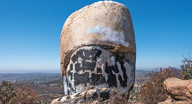
Unfortunately, the tooth is covered in graffitti
The out-and-back trip is an easy walk through coastal sage scrub and grassland habitat, with an occasional dip into shady live oak, poplar, sycamore and willow riparian groves. It is good for everyone, including parents with children. The loop hike up to and returning from Tooth Rock, on the other hand, is a more aerobic workout that will require more stamina and effort, not only because of its length and elevation gain, but also because the trail has not been well maintained. Trekking poles are advised for this part of the hike. On a clear day, the ocean view from Tooth Rock is sublime. The best time to explore this area is after the rains come and the wildflowers begin to appear, approximately from February through June, but it is enjoyable at any time of the year.
The trail begins in a riparian habitat, with shade provided by California live oaks and willows, and also a few native California black walnut trees. You are crossing private property for which the owner has granted passage. Soon you will enter Poway City-controlled land, on a trail it no longer maintains. Use it at your own risk, but the risks are minimal over the first mile.
As the sandy trail leaves the riparian habitat, it remains mostly above it for the next 0.5 mile and crosses coastal sage scrub habitat. Here you will find an abundance of wildflowers in season, including showy penstemon, deer weed, and blue elderberry. California buckwheat blooms nearly year-round, while in late summer and fall you can expect to see the bright yellow flowers of San Diego goldenbush, snakeweed, and sawtooth goldenbush.
At 0.5 mile from the trailhead, a trail curves off to the left, north, and ascends the ridge to Tooth Rock. You will return on this trail if you take the Tooth Rock loop, but ignore it for now. In another 0.2 mile, cross Rattlesnake Creek Bed. After ascending its east bank, a trail branches off to the left and continues up Rattlesnake Creek canyon. On some maps, this is designated as the Tooth Rock Trail, though it is not so signed here. For both the Tooth Rock loop and the out-and-back trip, take this trail as it curves and heads in a northerly direction, just above the Rattlesnake Creek bed.
The trail mostly avoids the densely forested creek bed and takes you through coastal sage scrub habitat. For about 0.4 mile, it is easy walking, but at 1.1 miles from the starting point, you will come to a trail washout in a riparian thicket where Rattlesnake Creek and a tributary meet. This is the where those looking for a shorter out-and-back hike should turn back and return to the trailhead the way they came.
Getting around the washout will require climbing about 10 feet down a soft dirt embankment to the creek bed, then climbing up the other side. Other hikers who have gone before you left a trail you can follow. At some time in the past, an improvised makeshift bridge was constructed to get around the washout, but it has since collapsed and now lies on the streambed.
Once you are past the washout, the trail resumes up the unnamed Rattlesnake Creek tributary in a northwesterly direction for 0.3 mile, then makes a hairpin turn and continues southeasterly on the other side of this same unnamed canyon. After gaining some altitude, the trail crosses the ridge and proceeds north in the next drainage. At the head of this canyon, the trail turns toward the west and ascends up a slope to the crest of the ridge containing Tooth Rock. On reaching the crest, take the trail to the left to reach Tooth Rock.
Tooth Rock is a large weathered granite boulder, similar to those found in abundance on Mt. Woodson and elsewhere in these coastal foothills. It stands alone, like a giant incisor with a decayed crown and an unbrushed base. The best part of Tooth Rock is the view it provides of the coastal plain, Twin Peaks, and out to the Pacific.
When you are ready to leave, go north on the trail you took to get here, turn right when you get to the junction and continue east down the trail. When you reach the first trail branching off to the right, take it. This trail continues down the side of the canyon, becoming progressively steeper, until it joins the main Rattlesnake Creek Trail, a half- mile from the trailhead.
RATTLESNAKE CREEK & TOOTH ROCK (Poway)
Find a taste of serenity and peace in a beautiful natural setting on a lesser-traveled Poway trail.
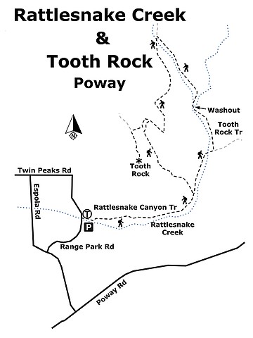
Rattlesnake Creek & Tooth Rock map
Driving Directions: (Poway) From I-15, exit onto Ted Williams Parkway, exit 19. Continue north east for 5.4 miles to Twin Peaks Road. Go right on Twin Peaks Road and continue east 2.3 miles to Espola Road. Turn right on Espola Road and drive another 0.4 mile to Range Park Road, on your left. Follow Range Park Road 0.3 mile to the trailhead, on your right. Hiking length: 2.2 miles out-and-back or a 3.4-mile loop. Allow 1 or 2.5 hours hiking time. Difficulty: Easy with elevation gain/loss of 187 feet or moderate with elevation gain/loss of 825 feet, depending on option chosen. The trail is open to hikers, non-motorized bicycles, and equestrians. Leashed dogs allowed.
Here's something you might be interested in.
Poway's trail less traveled
Hike the loop to Tooth Rock
Poway's trail less traveled
Hike the loop to Tooth Rock
Unfortunately, the tooth is covered in graffitti
The out-and-back trip is an easy walk through coastal sage scrub and grassland habitat, with an occasional dip into shady live oak, poplar, sycamore and willow riparian groves. It is good for everyone, including parents with children. The loop hike up to and returning from Tooth Rock, on the other hand, is a more aerobic workout that will require more stamina and effort, not only because of its length and elevation gain, but also because the trail has not been well maintained. Trekking poles are advised for this part of the hike. On a clear day, the ocean view from Tooth Rock is sublime. The best time to explore this area is after the rains come and the wildflowers begin to appear, approximately from February through June, but it is enjoyable at any time of the year.
The trail begins in a riparian habitat, with shade provided by California live oaks and willows, and also a few native California black walnut trees. You are crossing private property for which the owner has granted passage. Soon you will enter Poway City-controlled land, on a trail it no longer maintains. Use it at your own risk, but the risks are minimal over the first mile.
As the sandy trail leaves the riparian habitat, it remains mostly above it for the next 0.5 mile and crosses coastal sage scrub habitat. Here you will find an abundance of wildflowers in season, including showy penstemon, deer weed, and blue elderberry. California buckwheat blooms nearly year-round, while in late summer and fall you can expect to see the bright yellow flowers of San Diego goldenbush, snakeweed, and sawtooth goldenbush.
At 0.5 mile from the trailhead, a trail curves off to the left, north, and ascends the ridge to Tooth Rock. You will return on this trail if you take the Tooth Rock loop, but ignore it for now. In another 0.2 mile, cross Rattlesnake Creek Bed. After ascending its east bank, a trail branches off to the left and continues up Rattlesnake Creek canyon. On some maps, this is designated as the Tooth Rock Trail, though it is not so signed here. For both the Tooth Rock loop and the out-and-back trip, take this trail as it curves and heads in a northerly direction, just above the Rattlesnake Creek bed.
The trail mostly avoids the densely forested creek bed and takes you through coastal sage scrub habitat. For about 0.4 mile, it is easy walking, but at 1.1 miles from the starting point, you will come to a trail washout in a riparian thicket where Rattlesnake Creek and a tributary meet. This is the where those looking for a shorter out-and-back hike should turn back and return to the trailhead the way they came.
Getting around the washout will require climbing about 10 feet down a soft dirt embankment to the creek bed, then climbing up the other side. Other hikers who have gone before you left a trail you can follow. At some time in the past, an improvised makeshift bridge was constructed to get around the washout, but it has since collapsed and now lies on the streambed.
Once you are past the washout, the trail resumes up the unnamed Rattlesnake Creek tributary in a northwesterly direction for 0.3 mile, then makes a hairpin turn and continues southeasterly on the other side of this same unnamed canyon. After gaining some altitude, the trail crosses the ridge and proceeds north in the next drainage. At the head of this canyon, the trail turns toward the west and ascends up a slope to the crest of the ridge containing Tooth Rock. On reaching the crest, take the trail to the left to reach Tooth Rock.
Tooth Rock is a large weathered granite boulder, similar to those found in abundance on Mt. Woodson and elsewhere in these coastal foothills. It stands alone, like a giant incisor with a decayed crown and an unbrushed base. The best part of Tooth Rock is the view it provides of the coastal plain, Twin Peaks, and out to the Pacific.
When you are ready to leave, go north on the trail you took to get here, turn right when you get to the junction and continue east down the trail. When you reach the first trail branching off to the right, take it. This trail continues down the side of the canyon, becoming progressively steeper, until it joins the main Rattlesnake Creek Trail, a half- mile from the trailhead.
RATTLESNAKE CREEK & TOOTH ROCK (Poway)
Find a taste of serenity and peace in a beautiful natural setting on a lesser-traveled Poway trail.
Rattlesnake Creek & Tooth Rock map
Driving Directions: (Poway) From I-15, exit onto Ted Williams Parkway, exit 19. Continue north east for 5.4 miles to Twin Peaks Road. Go right on Twin Peaks Road and continue east 2.3 miles to Espola Road. Turn right on Espola Road and drive another 0.4 mile to Range Park Road, on your left. Follow Range Park Road 0.3 mile to the trailhead, on your right. Hiking length: 2.2 miles out-and-back or a 3.4-mile loop. Allow 1 or 2.5 hours hiking time. Difficulty: Easy with elevation gain/loss of 187 feet or moderate with elevation gain/loss of 825 feet, depending on option chosen. The trail is open to hikers, non-motorized bicycles, and equestrians. Leashed dogs allowed.
Comments