Here's something you might be interested in.
Ask a Hipster — Advice you didn't know you needed
Big Screen — Movie commentary
Blurt — Music's inside track
Booze News — San Diego spirits
Classical Music — Immortal beauty
Classifieds — Free and easy
Cover Stories — Front-page features
Drinks All Around — Bartenders' drink recipes
Excerpts — Literary and spiritual excerpts
Feast! — Food & drink reviews
Feature Stories — Local news & stories
Fishing Report — What’s getting hooked from ship and shore
From the Archives — Spotlight on the past
Golden Dreams — Talk of the town
The Gonzo Report — Making the musical scene, or at least reporting from it
Letters — Our inbox
Movies@Home — Local movie buffs share favorites
Movie Reviews — Our critics' picks and pans
Musician Interviews — Up close with local artists
Neighborhood News from Stringers — Hyperlocal news
News Ticker — News & politics
Obermeyer — San Diego politics illustrated
Outdoors — Weekly changes in flora and fauna
Overheard in San Diego — Eavesdropping illustrated
Poetry — The old and the new
Reader Travel — Travel section built by travelers
Reading — The hunt for intellectuals
Roam-O-Rama — SoCal's best hiking/biking trails
San Diego Beer — Inside San Diego suds
SD on the QT — Almost factual news
Sheep and Goats — Places of worship
Special Issues — The best of
Street Style — San Diego streets have style
Surf Diego — Real stories from those braving the waves
Theater — On stage in San Diego this week
Tin Fork — Silver spoon alternative
Under the Radar — Matt Potter's undercover work
Unforgettable — Long-ago San Diego
Unreal Estate — San Diego's priciest pads
Your Week — Daily event picks
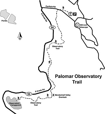
Palomar Mountain: Observatory Trail

Mendenhall Valley, viewed from the Observatory Trail, is part of a working cattle ranch.
The Palomar Mountain Observatory Trail is one of only four National Recreation Trails in San Diego County. From the tree-shaded, well-maintained trail there are bucolic vistas of grassy meadows with grazing cattle. It also provides a chance to visit the Hale Telescope and the world-class Palomar Observatory. It is easily accessible and is a rewarding hike year-round.
Palomar Mountain rises steeply from the Pauma Valley in the west and the Temecula Creek valley in the east, but the mountain itself consists of gentle rolling hills blanketed by a lush mixed forest of conifers and oaks with scattered patches of chaparral. The hills are interspersed with broad, grassy valleys, possibly reminding one of Vermont. The highest point on Palomar Mountain, called High Point (6140 feet in elevation), can be reached by car from the town of Oak Grove on the east side, but is not often visited by the thousands of visitors that flock to the mountain to frolic in the winter snow or camp at one of the campgrounds. Palomar Mountain also is the home of the 200-inch Hale Telescope, only 2 miles from the campground and the trailhead.
The Palomar Mountain Observatory, operated by Caltech and open to the public, has made fundamental discoveries about some of the most distant points of the universe and continues to be an important contributor to astronomy. The telescope and a small nearby museum are open to visitors daily.
While Palomar Mountain is a delightful place to visit or for car camping, it has relatively few public trails. In part, this is because much of the mountain is in private ownership. Mendenhall and Dyche valleys are working cattle ranches without public access. Hiking trails can be found in Palomar Mountain State Park, but continued access to its 14 miles of trails is now in doubt due to the possible closure of the park for budgetary reasons.
The Observatory Trail leaves the campground and parallels the road leading to Palomar Observatory, although the road mostly cannot be seen or heard from the trail. The trail passes through a highly varied forest, at times consisting of dense stands of coast live oak and scrub oak, interspersed with ponderosa and Jeffery pines, while at other times it passes through glades of western red cedar. Deciduous black oaks provide autumn color as their leaves become golden, but they reemerge in the spring in a delicate pink before assuming the deep green of summer.
Canyoneers are San Diego Natural History Museum volunteers trained to lead interpretive nature walks that teach appreciation for the great outdoors. For a schedule of free public hikes, refer to the San Diego Natural History Museum website.
Distance from downtown San Diego: 80 miles. Allow 1 hour and 40 minutes’ driving time. Take I-15 north past Escondido, exiting on Hwy 76 east toward Pala. After 20 miles, take either South Grade Road or East Grade Road to Crestline. South Grade is shorter but steep and windy. East Grade is much longer but climbs gradually through forests of stately oaks and conifers. Canfield Road extends east from Crestline 2.5 miles to the Cleveland National Forest’s Observatory Campground. Follow signs for the Observatory trailhead parking. An Adventure Pass is required.
Hiking length: 4.4 miles out and back. Allow 2 hours.
Difficulty: Easy to moderate because of the elevation gain/loss of 750 feet in 2.2 miles.
Here's something you might be interested in.
Palomar Mountain: Observatory Trail
Palomar Mountain: Observatory Trail
Mendenhall Valley, viewed from the Observatory Trail, is part of a working cattle ranch.
The Palomar Mountain Observatory Trail is one of only four National Recreation Trails in San Diego County. From the tree-shaded, well-maintained trail there are bucolic vistas of grassy meadows with grazing cattle. It also provides a chance to visit the Hale Telescope and the world-class Palomar Observatory. It is easily accessible and is a rewarding hike year-round.
Palomar Mountain rises steeply from the Pauma Valley in the west and the Temecula Creek valley in the east, but the mountain itself consists of gentle rolling hills blanketed by a lush mixed forest of conifers and oaks with scattered patches of chaparral. The hills are interspersed with broad, grassy valleys, possibly reminding one of Vermont. The highest point on Palomar Mountain, called High Point (6140 feet in elevation), can be reached by car from the town of Oak Grove on the east side, but is not often visited by the thousands of visitors that flock to the mountain to frolic in the winter snow or camp at one of the campgrounds. Palomar Mountain also is the home of the 200-inch Hale Telescope, only 2 miles from the campground and the trailhead.
The Palomar Mountain Observatory, operated by Caltech and open to the public, has made fundamental discoveries about some of the most distant points of the universe and continues to be an important contributor to astronomy. The telescope and a small nearby museum are open to visitors daily.
While Palomar Mountain is a delightful place to visit or for car camping, it has relatively few public trails. In part, this is because much of the mountain is in private ownership. Mendenhall and Dyche valleys are working cattle ranches without public access. Hiking trails can be found in Palomar Mountain State Park, but continued access to its 14 miles of trails is now in doubt due to the possible closure of the park for budgetary reasons.
The Observatory Trail leaves the campground and parallels the road leading to Palomar Observatory, although the road mostly cannot be seen or heard from the trail. The trail passes through a highly varied forest, at times consisting of dense stands of coast live oak and scrub oak, interspersed with ponderosa and Jeffery pines, while at other times it passes through glades of western red cedar. Deciduous black oaks provide autumn color as their leaves become golden, but they reemerge in the spring in a delicate pink before assuming the deep green of summer.
Canyoneers are San Diego Natural History Museum volunteers trained to lead interpretive nature walks that teach appreciation for the great outdoors. For a schedule of free public hikes, refer to the San Diego Natural History Museum website.
Distance from downtown San Diego: 80 miles. Allow 1 hour and 40 minutes’ driving time. Take I-15 north past Escondido, exiting on Hwy 76 east toward Pala. After 20 miles, take either South Grade Road or East Grade Road to Crestline. South Grade is shorter but steep and windy. East Grade is much longer but climbs gradually through forests of stately oaks and conifers. Canfield Road extends east from Crestline 2.5 miles to the Cleveland National Forest’s Observatory Campground. Follow signs for the Observatory trailhead parking. An Adventure Pass is required.
Hiking length: 4.4 miles out and back. Allow 2 hours.
Difficulty: Easy to moderate because of the elevation gain/loss of 750 feet in 2.2 miles.
Comments